Document Actions
Geology, climate & hydrology
 |
|
|
Generalized geologic map showing major rock units and fault traces in the Santa Clara River watershed. Adobe PDF (2MB). Stillwater Sciences. |
Geology
The Santa Clara River watershed is located within a geologically active area, within the San Andreas Fault system, which forms the dynamic boundary between the Pacific and North America tectonic plates. Relative motion of the plates includes strike-slip displacement (along the trend of the fault zone) and convergence (acting perpendicular to the fault zone). Convergence along the boundary has led to rapid uplift in coastal and interior mountain ranges throughout the region (Orme 1998; Duvall et al. 2004; Blythe et al. 2000).
Persistent regional geologic instability since about 28 million years ago (Ma) has exposed a wide variety of highly deformed, fractured, and faulted rock types in the Santa Clara River watershed (Yeats and Rockwell 1991; Rockwell et al. 1984; Rockwell 1988). Igneous and metamorphic rocks, including gneiss, schist, and granite, dominate in the upper watershed to the east, while younger sedimentary and volcanic rocks are more prevalent in the lower watershed, west of the San Gabriel Fault. Fractures, deformation, and faulting contribute to high bedrock erodiblity throughout the watershed. For example, the sedimentary bedrock along the mainstem valley flanks is often poorly consolidated, intensely folded, and has steeply tilted beds, making it susceptible to landsliding (e.g., Harp and Jibson 1996) and erosion by dry raveling (Scott and Williams 1978). Even areas underlain by granite, gneiss, and schist (which are normally thought to be relatively resistant to erosion) have been described as being highly erodible (e.g., Scott and Williams 1978; Wells et al. 1987), due to extensive deformation and fracturing. The position of unchanneled valleys, creeks, and the Santa Clara River itself are strongly influenced by geologic structure and the location of active faults. Below its confluence with Sespe Creek, the river roughly follows the axis of a west-trending synclinal valley, which is bounded by active strands of the San Cayetano Fault (Rockwell 1988) to the north and the Oak Ridge Fault (Azor et al. 2002) to the south.
Intense seismic activity in the region is reflected in frequent ruptures along faults. Seven of the roughly 30 high-magnitude (MW ≥6) earthquakes that have shaken southern California over the past 80 years have occurred in the Transverse Ranges (numbers updated from Rockwell 1988). Seismic shaking during the magnitude 6.7 Northridge event in 1994 triggered nearly 7,400 landslides in the watershed (Harp and Jibson 1996), highlighting the importance of geologic factors in the production of sediment, which ultimately affects geomorphic processes in the lower river corridor
Climate and hydrology
 |
|
|
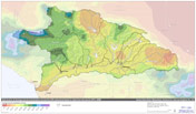
Distribution of mean annual precipitation based on PRISM precipitation data. Adobe PDF (2MB). Stillwater Sciences. |
Watersheds of southern California function according to a semi-arid, two-season Mediterranean-type climate, with cool wet winters and dry warm-to-hot summers. Within the Santa Clara River watershed, proximity to the Pacific Ocean moderates both seasonal and diurnal temperatures. Air moisture is greatest at the coast and decreases to near-desert conditions towards the eastern watershed boundary. Most precipitation occurs between November and March, with rainfall intensities varying significantly throughout the watershed due to complex topographic features. For example, average annual rainfall is more than 860 mm (34 in) in the mountainous headwaters of Sespe Creek, while only about 200 mm (8 in) in the drier eastern portions of the watershed near the Mojave Desert (PWA 2003).The climatic and hydrologic characteristics of the watershed generally produce an intermittent flow regime in the mainstem Santa Clara River. Consistent with other rivers in the region, the Santa Clara River watershed experiences highly variable annual rainfall and peak flows. During the rainy season, flows can increase, peak, and subside rapidly in response to high intensity rainfall (the term “flashy” is commonly used to describe this characteristic), with the potential for severe flooding under saturated or near-saturated watershed conditions. Between winter rainfall events in wet years, the river may exhibit continuous baseflow to the ocean from residual watershed discharge; in dry years, flow may be intermittent.
During the dry summer season, flows in the mainstem are intermittent or non-existent, depending primarily on areas of rising groundwater or inflows from dam releases or other anthropogenic sources. Groundwater discharges to the mainstem Santa Clara River occur when groundwater levels are high and the water table is close to the surface. In the lower Santa Clara River, two geologic features are important to surface water-groundwater interactions on the mainstem – the Piru and Fillmore narrows. In these locations, constrictions in the width of unconsolidated deposits, combined with subsurface bedrock controls cause groundwater to rise and discharge to the Santa Clara River, depending on groundwater levels and surface flow conditions (URS In review). In areas away from the bedrock controls, surface flow is lost through the highly permeable bed materials to groundwater. Generally, flows in the river are relatively small–75% of the time flows are less than 4.2 m3s-1 (150 cfs) at Montalvo and 50% of the time flows are less than 0.3 m3s-1 (10 cfs) (URS In review). However, large peak flows associated with winter storm events cause flows to exceed 2,832 m3s-1 (100,000 cfs) once every 10 years on average (URS In review).
 |
|
|
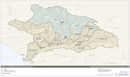
Areas within the Santa Clara River watershed regulated by major dams. Adobe PDF (2MB). Stillwater Sciences. |
Major tributaries of the Santa Clara River include Santa Paula, Sespe, Hopper, Piru, Castaic, San Francisquito, and Bouquet Canyon creeks. Other tributaries, including numerous barrancas (small, generally incised tributary streams) and unnamed ephemeral creeks empty into the mainstem river along its course. More than one-third of the watershed area lies upstream of dams and debris basins that regulate water and/or sediment discharge to the lower river corridor. Major dams include Santa Felicia Dam on Piru Creek and Castaic Dam on Castaic Creek. Throughout the year, controlled releases of water from Piru Reservoir supplement surface flows in the river reach in Ventura County. Additional flow is supplied from water reclamation plant discharges and imported water runoff in the middle reach from the vicinity of Santa Clarita in Los Angeles County down to the Ventura County line.
Text adapted from the Santa Clara River Parkway Floodplain Restoration Feasibility Study: Assessment of Geomorphic Processes. Graphics adapted from the upcoming Assessment of Geomorphic Processes for the Santa Clara River Watershed, Ventura and Los Angeles counties, California