The Santa Clara River

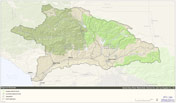
The Santa Clara River watershed. |
The Santa Clara River flows for 116 miles through northern Los Angeles County and southern Ventura County, in southern California. With headwaters in the San Gabriel Mountains, the river empties into the Pacific Ocean near the city of Ventura, draining a watershed of approximately 1,600 square miles.
Many large coastal southern California rivers (e.g. the Los Angeles, Santa Ana, and San Gabriel rivers) have been drastically modified to provide for flood protection and urban development, reducing the influence of natural physical and biological processes that maintain aquatic and riparian habitat. While the Santa Clara River has been impacted by flood control and water resources infrastructure, urban development and agriculture, the river continues to possess many of the historical attributes of lowland coastal southern California rivers, including a broad, dynamic floodplain, extensive riparian vegetation, and a large coastal lagoon.
The Santa Clara River and its tributaries experience high annual flow variability, multi-year droughts, and extreme seasonal flooding, resulting in a complex matrix of aquatic and riparian habitats that suport a number of endangered and threatened species. These include the tidewater goby (Eucyclobius newberryi), arroyo toad (Bufo microscaphus californicus), southwestern willow flycatcher (Empidonax trailii extimus), least Bell’s vireo (Vireo bellii pusillus), and slender-horned spineflower (Dodecahema leptoceras). The Santa Clara River also supports a remnant run of federally endangered southern steelhead (Oncorhynchus mykiss). The run is much reduced from pre-1950’s levels estimated to have been on the order of about 9,000 adults, making the watershed a focus for regional steelhead recovery efforts.
To learn more:
- Read about featured wildlife and plants of the Santa Clara River
- Become familiar with the geology, climate, and hydrology of the Santa Clara River watershed
- Learn about the "fire-flood sequence" and its effects on the Santa Clara River
- Explore the Santa Clara River watershed using Google Earth
- Check out the recommended reading list to learn more about the history of the Santa Clara River, its physical context and biological resources
- Read about the Santa Clara River Parkway project, browse the watershed knowledge base, or get an overview of the Parkway website
Top photo: the lower Santa Clara River in flood, January 2005. Photo courtesy of the Santa Paula Airport Association.