Document Actions
The Santa Clara River Parkway project
 |
|
|
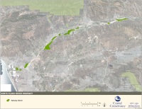
Click the above image to use Google Maps to |
In 2000, the California State Coastal Conservancy proposed the establishment of the Santa Clara River Parkway after discussions with river corridor landowners and local governments. The primary goal of the Santa Clara River Parkway Project is the acquisition, conservation, and restoration of floodplain lands within the Santa Clara River corridor. Governor Gray Davis provided initial funding of $9.2 million, as appropriated by the legislature, to the Coastal Conservancy for land acquisition and planning. Land acquisition is being conducted on a willing seller basis, with the initial focus of the project on the lower river. To date over 3,000 acres and nearly 15 miles of river corridor have been acquired.
As currently envisioned, the Parkway project will result in the acquisition and restoration of a 25 mile-long, or 6,000-acre, corridor from the mouth of the Santa Clara River to the Sespe Creek confluence. The Coastal Conservancy has partnered with The Nature Conservancy's LA-Ventura Project to acquire, manage, and restore Parkway lands. Future management of Parkway lands is expected to be carried out under a joint powers agreement between the Coastal Conservancy, Ventura County and the cities of Oxnard and Ventura.
Goals of the Parkway Project
The Parkway was established to achieve three goals:
- conserve and restore aquatic and riparian habitat for native species, and the hydrologic and geomorphic processes that create and maintain those habitats;
- provide enhanced flood protection for adjacent private land and public facilities;
- provide public access and environmental education, including the creation of a continuous public trail system along the length of the Parkway.
Parkway planning
Planning for Parkway management and restoration began with the Santa Clara River Parkway Floodplain Restoration Feasibility Study. The Feasibility Study was designed to assist the Coastal Conservancy and its partners with the development of restoration and management strategies for acquired Parkway lands.
Parkway planning is continuing with the development of a strategic plan for nonnative invasive arundo (giant reed) treatment, a recreation and public access plan, and modeling of levee setback scenarios on acquired Parkway lands.
More informationFor more information about the Santa Clara River Parkway project contact the Coastal Conservancy project manager, Peter Brand brand@scc.ca.gov. Learn more about the Parkway website or contact us.
Top image: mapping of historical flood effects along the lower Santa Clara River, using aerial photography from 1938-2005 (Stillwater Sciences).